GPS Waypoints Navigator
- 4.7
- Rating
- 50.00K
- Installs
- $6.99
- Price
 Analysis by App-foxy
I approached GPS Waypoints Navigator as a practical tool rather than a general-purpose map replacement. Its focus is clear: helping me mark, save, and navigate to locations when I am hiking, traveling by boat, or driving away from ordinary roads. That narrow purpose is also its biggest appeal. Instead of trying to become a social map, a city guide, and a trip planner at the same time, it puts waypoints at the center of the experience.
After using it, my impression is that this is best understood as a field navigation companion. It suits someone who wants to record a trail junction, return to a campsite, mark a fishing spot, or keep a reliable reference for an offroad destination. It is less attractive if all I need is turn-by-turn driving directions between familiar streets. The app is developed by Disciple Skies Software, carries an average rating of 4.7 from around four thousand ratings, and has passed fifty thousand installs, which gives it a reassuring history without making it feel like a mass-market navigation platform.
How the current version fits real outdoor navigation
The current version is 9.36, and the long life of the product matters here. GPS tools are not judged only by visual polish; they need to remain dependable when I am outside, away from the habits and conveniences of urban navigation. The app was released on June 28, 2012, so it has had plenty of time to develop a focused identity. I would not describe it as a trendy mapping app. I would describe it as a specialized instrument for people who think in coordinates, destinations, and return points.
You May Also Like

 Blood Strike: 2.5 Anniversary
Blood Strike’s Loadouts Turn Every Drop Into a Tactical Gamble
A close look at Blood Strike’s custom loadouts: how fast access to signature weapons reshapes its battle royale rhythm, rewards preparation, and narrows the gap between fights.

 Pandora - Music & Podcasts
Pandora’s Music Is Easy to Start, but Harder to Recover
Pandora’s strength is its low-effort path from a seed to a station. Its weak spot is how much confidence it asks you to place in connection, setup, and quiet recovery.

 8 Ball Pool
 Is Built on Rivalries, Rematches, and Routine
A close look at the rivalries, rematches, shared routines, and unanswered safety questions that turn a quick pool match into a persistent mobile community.

 Samsung Music
’s Quiet Strength Is Playing What You Already Own
Its reach comes less from spectacle than from dependable access to a personal library. That simplicity is both the app’s strongest retention engine and its ceiling.

 AccuWeather: Weather Radar
AccuWeather Review: A Quick, Clear Forecast for Everyday Decisions
For everyday plans, the best forecast is the one you can understand quickly. AccuWeather makes rain timing, radar, and local conditions easy to act on, with a few trade-offs.

 Hill Climb Racing
Why Hill Climb Racing Still Turns Crashes Into One More Run
A tiny car, a bumpy hill and one more upgrade: Hill Climb Racing keeps resurfacing because its simple chaos makes every near-miss feel personal.
More From Our News Desk



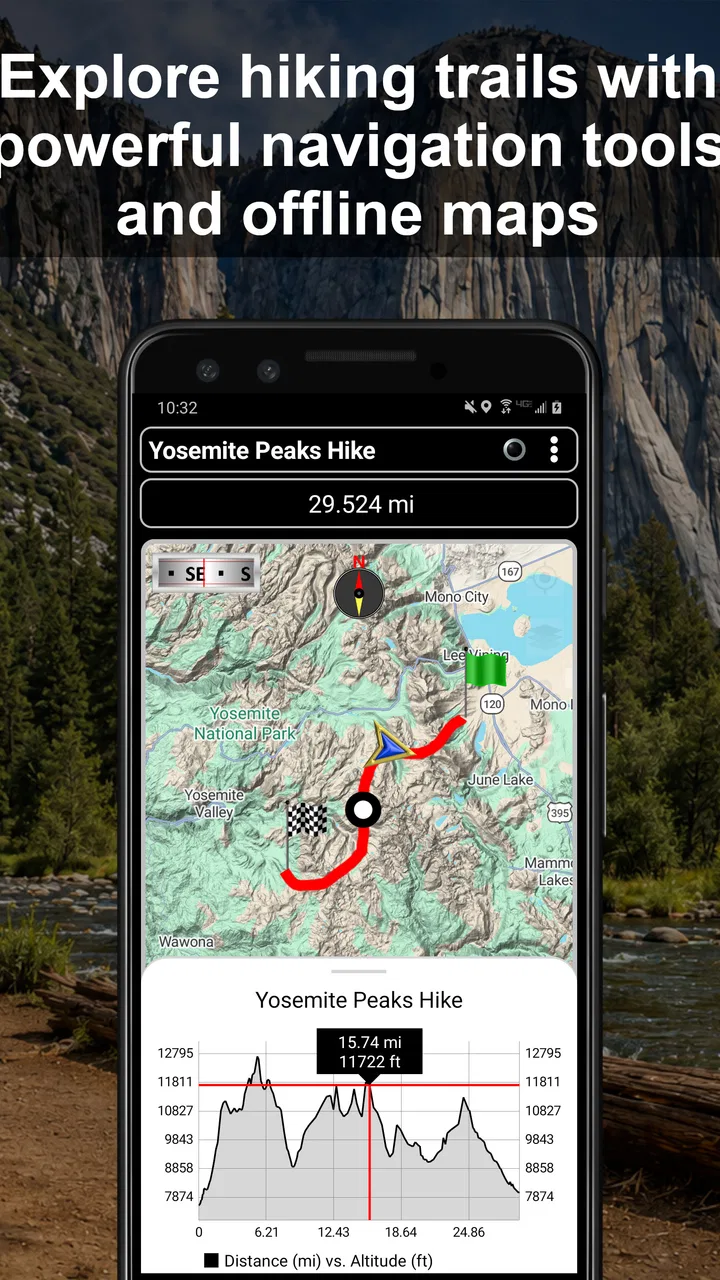
The basic idea is easy to understand. I can use the phone's location capability to establish where I am, save a waypoint, and use that saved point as a navigation reference later. That workflow is valuable because many outdoor destinations do not have a clean street address. A trailhead, hidden viewpoint, boat anchorage, remote gate, or vehicle left at the start of a route may be easier to find again through a stored waypoint than through a written description.
In everyday use, I would not treat the screen as a replacement for awareness. I would use it to answer practical questions: Am I moving toward the right place? Did I pass the junction where I intended to turn? Which saved point is the one I need to reach? Is the location I recorded at the start of the walk still available when I am ready to return? That makes the app useful even when I am not following a formal route.
One realistic example is a day hike with several confusing forks. Before leaving the parking area, I can save the vehicle's location. Along the walk, I can mark a water source, a junction, and a viewpoint. If weather changes or daylight fades, those points give me a set of references for retracing decisions instead of relying on memory. The value is not that the app magically understands the terrain; the value is that it preserves the locations I considered important.
Why waypoints are more useful than they first appear
A waypoint is often treated as a simple pin, but in outdoor navigation it can become a small record of a trip. I might use one to identify a safe place to leave a vehicle, another to mark where a path becomes difficult to see, and another to remember the exact position of a campsite or shoreline access point. This is more flexible than searching for a named place in a conventional map application.
There is also a useful distinction between planning and recovery. During planning, I can think about the places I expect to visit. During recovery, I use the phone to regain orientation after taking a wrong turn or returning from a detour. The same saved point serves both purposes, but the second use is where a dedicated waypoint tool earns its place. A normal map may show roads and popular locations well, yet it may not reflect the personal landmarks that matter on my particular trip.
For marine use, the same logic applies with different surroundings. A shoreline location, launch point, mooring reference, or productive area can be more meaningful than a road-based address. I would still regard it as an aid rather than a substitute for proper marine preparation. Water conditions, visibility, local rules, charts, and equipment remain important. The app can help me remember a position, but it cannot make an unfamiliar body of water safe by itself.
The practical workflow I would use before leaving
I would prepare the app before the trip instead of opening it for the first time at the destination. First, I would make sure the phone is charged and that the app is available on the device I intend to carry. Then I would create or review the waypoints that matter most: the starting point, the intended destination, and any places where I may need to make a decision. This keeps the field session focused and reduces the chance of hurried data entry.
I would also give each saved point a name that makes sense under pressure. “North trail junction” is more useful than a vague label, especially after several hours outside. A short note about why the point matters can be equally valuable. The best naming system is not complicated; it simply makes the saved location recognizable when I am tired, wearing gloves, or dealing with poor visibility.
A less obvious but important habit is to save the return point before starting the activity. People often think only about the destination, yet finding the car, boat launch, or access track again may be the more urgent task. Marking that location at the beginning creates a safety-oriented reference that remains useful even if the route changes later.
I would then test the whole workflow close to home. Saving a waypoint, selecting it, checking the navigation view, and returning to the saved point should feel familiar before I depend on it in a remote place. This is especially worthwhile for users moving from a standard map app, because a specialized navigation interface may organize information differently from the tools they already know.
What the long-running product tells me about its evolution
The version history represented by the current 9.36 release suggests continuity rather than a completely new direction. I see the product's evolution as refinement around its original purpose: outdoor, marine, and offroad navigation based on saved locations. That is a good sign for an established utility. A waypoint app does not need a new social feature every few months; it needs its central workflow to remain understandable and dependable.
At the same time, I would separate what the current version demonstrates from what I might hope to see in future updates. The confirmed current position is a mature app with a long release history and a focused navigation role. That does not automatically mean it has every modern convenience found in newer mapping services. I would judge it by how well it handles waypoint work, not by whether it resembles a fashionable map platform.
The product's age also explains why expectations should be realistic. A tool that began in the early smartphone era may prioritize function over elaborate presentation. For me, that is acceptable when the controls are clear and the information is easy to interpret outdoors. It becomes a problem only if the interface makes a simple task feel unnecessarily technical. Users who value animated maps, highly polished route discovery, or constant online recommendations may find the experience more utilitarian than they want.
Disciple Skies Software has kept the app available across a substantial period, and the current release gives existing users a stable point of reference. I would not assume that every update changes the way the app works. In a navigation utility, consistency can be a benefit: once I learn where to create a waypoint and how to navigate toward it, I do not want the core process redesigned without a good reason.
What existing users may notice in daily use
For someone who has used earlier versions, the main benefit of a current release is likely confidence that the app remains an active part of the developer's product line. That matters more than it sounds. Outdoor tools become part of a preparation routine, and users need to know which version they are opening and whether their familiar workflow still applies.
I would still recommend checking the app before an important trip rather than assuming that familiarity removes all risk. Open a saved waypoint, create a temporary test point, and confirm that the navigation view behaves as expected. This is not a criticism of this particular app; it is sensible practice for any phone-based navigation tool. A device change, operating-system update, or altered phone setting can affect the experience even when the app itself remains familiar.
The minimum operating-system requirement is Android 6.0, which makes the app accessible on a broad range of older compatible phones. That can be useful for outdoor users who keep a durable secondary handset for travel or field work. However, an older compatible operating system does not guarantee that every older phone will be pleasant to use. Screen brightness, battery condition, GPS performance, and weather resistance may matter more in the field than the app's basic compatibility.
The age rating is Everyone, so there is no adult-oriented positioning to worry about when considering it for a family device. In practical terms, though, younger users still need guidance about responsible navigation. Saving a location is simple; understanding terrain, weather, water hazards, and the limits of phone positioning requires experience. The app can support good judgment, but it cannot provide that judgment for the user.
Three field techniques that make it more useful
The first technique is to create a small waypoint system instead of collecting random pins. I would use a consistent pattern such as start point, decision point, destination, and return point. This prevents a long list of marks from becoming confusing. The goal is not to record everything; it is to record the locations that change what I do next.
The second is to use waypoints at transitions. A transition might be where a maintained path becomes a rough track, where a vehicle route ends, or where a shoreline approach changes. These points are often more useful than a pin at an obvious destination because they explain where the character of the journey changes. If I later revisit the area, I know where to slow down and reassess.
The third is to separate confidence from convenience. If the phone shows that I am near a saved point, I would still look around and compare the landscape with my expectations. Trees, rocks, water levels, and tracks can change. A waypoint tells me about a recorded position; it does not prove that the surrounding route remains open or safe. That distinction is essential when using the app for offroad travel.
A fourth technique is to avoid letting the screen become the only source of orientation. I would glance at the app, then look at the environment, then continue. Keeping a simple mental picture of the route makes the waypoint more useful and reduces dependence on continuous screen attention. This is particularly important while walking, driving offroad, or operating a boat, where looking down at a phone at the wrong moment creates its own hazard.
Where it falls short compared with ordinary alternatives
The usual map applications are better when I need business listings, live road information, public transit, familiar addresses, or turn-by-turn driving through populated areas. They are designed around discovering places and following established roads. If that is my main need, paying for a dedicated waypoint tool may feel unnecessary.
GPS Waypoints Navigator becomes more appealing when the destination is personal, remote, or poorly represented by mainstream mapping services. A conventional map may show the broad area, but the point I care about could be a private trail junction or a place I discovered myself. In that situation, a saved waypoint is more relevant than a search result.
Specialist outdoor mapping services may be a better choice for users who want rich terrain layers, community routes, detailed trail databases, or extensive trip planning in one package. Those services can make route discovery easier, particularly for people who do not already know where they want to go. The trade-off is that they may feel heavier and more complicated when all I want is to mark a position and return to it.
This app's focused design can also expose a limitation: it does not remove the need for preparation. I would not choose it as my only tool for a serious expedition without considering maps, communication, weather information, navigation backups, and local knowledge. Its strength is precise personal reference, not all-purpose expedition management.
There is also a learning curve for people accustomed to automatic navigation. In a city map, I can type an address and receive a sequence of road instructions. A waypoint-centered workflow asks me to think more actively about where I am, what I have saved, and what the destination means in the landscape. I see that as a worthwhile trade for experienced outdoor users, but it may frustrate someone expecting a fully guided route.
Who should pay for it, and who should skip it
The price is $6.99, so I would consider the purchase in relation to how often I spend time away from ordinary roads. For a regular hiker, boater, offroad driver, or landowner who repeatedly needs to remember locations, the focused function can justify the cost. A reliable saved point may be more valuable than another general map subscription if it solves a recurring problem.
I would skip it if my navigation life is limited to commuting, city driving, finding restaurants, and checking public transport. Those tasks are already handled more naturally by mainstream alternatives. I would also hesitate if I want a single app to provide a large catalog of trails, social recommendations, rich route planning, and broad travel discovery. This is not where its identity appears strongest.
It is a reasonable option for someone who wants a dedicated tool without committing to an elaborate outdoor platform. The Everyone rating and Android 6.0 minimum make it approachable from a device-compatibility perspective, while the mature release history suggests that it is not an abandoned experiment. Still, the buyer should be comfortable with a practical navigation tool rather than expecting a highly guided adventure service.
What I would watch before relying on it more heavily
My first concern would be how the app fits into a complete offline and low-connectivity routine. Outdoor users should test their planned workflow in the conditions where they expect to use it, not only at home with a strong connection and a full battery. I would verify that the relevant locations are saved, that I can recognize them, and that I understand the screen well enough to use it without constant experimentation.
I would also watch for future improvements that make waypoint organization faster without changing the app's focused character. Better sorting, clearer naming, easier review of saved points, and a smoother preparation workflow would all be meaningful because they directly reduce field confusion. I would prefer those kinds of improvements over unrelated extras.
For existing users, the important question is whether updates continue to preserve the dependable core. A navigation app can become less useful if essential actions are buried under decorative changes. The current version gives me a solid reason to view the product as established, but I would still assess future releases by their effect on saving, finding, and navigating to personal locations.
My final view is positive, with a clear boundary. This is a specialized Maps & Navigation app that I would recommend to a friend who regularly needs to return to places that ordinary maps do not describe well. Its strongest idea is simple but practical: make important locations personal, memorable, and usable later. The combination of a mature product, a focused purpose, and a manageable one-time price makes it appealing for the right audience.
I would not recommend it as a universal replacement for city maps or as the sole safety system for demanding trips. I would recommend it as a waypoint instrument that rewards preparation and sensible outdoor habits. If I were heading to an unfamiliar trail, remote access road, or shoreline location, I would rather have my own carefully named reference points than depend entirely on memory. For hikers, marine users, and offroad travelers who value control over convenience, this app earns its place on the phone.
FAQs for GPS Waypoints Navigator
01What is GPS Waypoints Navigator used for?
GPS Waypoints Navigator is designed to help users save, organize, and navigate to specific geographic locations, commonly called waypoints. It can be useful for hiking, camping, boating, fishing, surveying, traveling, geocaching, or marking a parked vehicle. After saving a location, you can view its coordinates and use navigation guidance to return to it, even when exploring unfamiliar areas.
02Does GPS Waypoints Navigator work without an internet connection?
The app can generally use your device’s GPS receiver to determine your position without mobile data, which is helpful in remote areas. However, some features may depend on an internet connection, especially online maps, map tiles, address searches, route information, or satellite imagery. Before going offline, users should check whether the required maps can be downloaded or cached in advance.
03How accurate are the locations recorded by the app?
The accuracy of saved waypoints depends mainly on your phone’s GPS hardware, satellite visibility, weather, surrounding buildings, trees, and whether location services are properly enabled. In open areas, the position can often be reasonably accurate, but it may become less precise indoors or near obstacles. Always review the displayed accuracy before relying on a waypoint for safety-critical navigation.
04Can I import, export, or share waypoints with other devices?
GPS Waypoints Navigator may support exchanging waypoint information through common location formats or sharing tools, depending on the version and device platform. This can make it easier to back up saved points, move them to another phone, or share a meeting location with someone else. Check the app’s available export and sharing options before storing important navigation data exclusively inside the application.
05Is GPS Waypoints Navigator suitable for serious outdoor navigation?
The app can be a practical companion for recording locations and finding your way back to important points, but it should not be your only navigation tool during demanding outdoor activities. Phone batteries can run out, GPS signals can be interrupted, and digital maps may contain errors. For hiking, boating, or remote travel, carry a paper map, compass, backup power, and follow local safety guidance.
Pros
- Works offline once maps and waypoint data are downloaded.
- Supports importing and exporting common GPS file formats.
- Useful waypoint tools for hiking
- boating
- camping
- and fieldwork.
- Displays accurate location details
- including coordinates and altitude.
- Can record tracks and save points for later navigation.
Cons
- Some advanced navigation features may require a paid upgrade.
- Offline maps can consume considerable storage space on your device.
- The interface may feel complex for users new to GPS navigation.
- Battery usage increases during continuous GPS tracking.
- Map coverage and detail depend on the selected map source.

GPS Waypoints Navigator
Gallery